Ce site présente un travail effectué essentiellement à partir de cartes de pêche hauturière de marins d'Etel (Morbihan).
Le titre 'Rebattre les cartes' - c'est-à-dire recommencer à zéro - s'est imposé naturellement; ces cartes de travail ont désormais une autre finalité car leur recouvrement en a changé la signification: le territoire graphique recouvre (remplace? ) le territoire géographique en une sorte de palimpseste qui superpose et entrelace les surfaces.
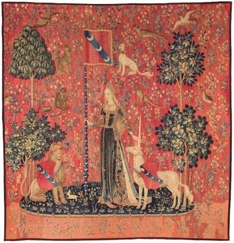
Cette série s'inspire des tapisseries des XVe et XVIe siècles de style Mille-Fleurs (voir ici) dont le plus célèbre example est La Dame à La Licorne: surface couverte de fleurs et animaux réels ou imaginaires, non-respect des échelles des éléments les uns vis à vis des autres.
Toute carte est un ensemble de signes et symboles formant un langage propre (les réseaux d'hyperbole tracés en Rouge, Vert et Violet sur les cartes Decca par exemple, les échelles de distance, les compas...). S'y ajoutent mesures, commentaires et annotations personnelles. Un choix entre ces éléments s'est donc imposé afin de ne pas surcharger les oeuvres et conserver leur équilibre.
Les côtes et les mers ont été abondamment représentées en peinture, les fonds marins peu. Ce sont surtout la photo et la vidéo qui nous en révèlent les richesses. Or les océans occupent environ 70% de la surface de la planète et récèlent encore de nombreux mystères.
Un beau champ d'exploration pour l'art.


This website presents a series of works essentially based on deep-sea fishing charts belonging to skippers from Etel, Brittany.
It is entitled 'rebattre les cartes' which is a pun on the word 'cartes' meaning both 'cards' as well as 'maps' and 'charts' in French. 'Rebattre les cartes' means reshuffling the cards (charts here), i.e. start all over again. This is what has happened to these deep-sea fishing charts: they used to be work maps and now have been completely repurposed. The graphical territory recovers the geographical territory in a sort of palimpsest that superimposes and interlaces surfaces.
This series was inspired by the Millefleur style of the 15th and 16th century tapestries where there is a profusion of real and imaginary animals and plants in distorted scales. The most famous example in France is The Lady and The Unicorn.(see here)
Any chart or map uses a series of signs and symbols (such as the hyperbolic lines printed in Red, Green and Purple on the decca charts, scales, compass...) as well as notes, information and cautions; it was immediately clear that they could not all be kept and only those which contributed to the balance of the final result were retained.
The shores, beaches, coastlines and the sea have been favourite topics in painting. Not so much underwater worlds. Their richness has mostly been revealed by photos and videos. Oceans occupy about 70% of the surface of our planet and many of their treasures are still unknown.
A great field of exploration for art.
These series of charts have been preceded by numerous drawings and watercolours of rocky shores and beaches and sea wrack strewn on the foreshore.
Cartography and the realm of imagination have always fed off each other. Medieval and Renaissance portolans often displayed an imaginary world of faraway voyages on dangerous seas towards mysterious destinations. Cartographers embellished them with ornamentation as well as strange and threatening creatures symbolizing both their expectations and apprehensions. Beautiful charts showing nonexistent lands and islands spurred explorers on to launch risky expeditions.
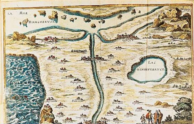
In the 17th century maps and charts took on another dimension with the famous carte de Tendre (map of Tendre) - a topographical representation of an imaginary land showing paths towards successful love lives (see here). Today social science constantly maps our emotions, desires, fears...There is a constant movement back and forth between an elusive reality and the mapmaker's standpoint and motivations.
Artists have turned maps and charts into a new tool of expression through drawings, paintings, collages, installations, sculptures or videos, so as to explore new aesthetic territories for, as Guillaume Sibertin-Blanc writes in his study of Gilles Deleuze's use of mapping, "[mapping] is not a way of reproducing an alleged pre-existing reality but a creative processing operation to discover new realities".
Maps are highly codified artefacts. A shift, however slight, in the use of their intricate web of codes and signs opens up opportunities which this series of imaginary charts aims at exploring.
Le travail sur les cartes s'est nourri de nombreux dessins et aquarelles des bords de mer, de ses rochers, ainsi que des plages et de leurs laisses de mer.
Cartographie et imaginaires ont toujours entretenu un rapport dialectique fécond. Les portulans du Moyen-Age et de la Renaissance en particulier projetaient un imaginaire de voyages lointains, sur des mers dangereuses, vers des destinations mystérieuses. Les cartographes y ajoutaient de riches décorations et des créatures étranges et menaçantes symbolisant à la fois leurs attentes et leur appréhension de ces mondes inconnus. De splendides cartes de terres et d'îles inexistantes incitèrent des explorateurs à se lancer dans des aventures hasardeuses.
Au XVIIe siècle la carte prend une nouvelle dimension avec la célèbre Carte de Tendre: représentation topographique de l'imaginaire des relations amoureuses (voir ici). Aujourd'hui les sciences sociales cartographient sans cesse nos émotions, nos désirs, nos peurs... Il y a donc un va-et-vient constant entre le point de vue et les motivations de celui qui cartographie et une réalité qui se dérobe.
Les artistes se sont approprié les cartes en les déclinant sous toutes les formes (dessins, peintures, collages, installations, sculptures ou vidéos) pour explorer de nouveaux territoires esthétiques car, comme l'écrit Guillaume Sibertin-Blanc dans son étude de l'usage de la cartographie chez Gilles Deleuze, "[La carte] n'est pas un moyen de reproduire une réalité supposée préexistante mais un opérateur d'opération et de découverte créatrice de réalités nouvelles."
Les cartes sont des artefacts très codifiés. Une modification, même légère, de leur réseau complexe de codes et de symboles ouvre de nouveaux champs d'investigation que cette série de cartes imaginaires se propose d'explorer.